When earthquakes are large and shallow, they act like giant subwoofers, shaking the ground and making sound. I’ve got a bit of a long-standing interest when it comes to infrasound (low-frequency sound) from earthquakes from Utah. I wrote a paper 8 years ago on understanding the infrasound generated by an earthquake in Southern Utah. When I heard there was a Magnitude 5.7 earthquake near Salt Lake City this week, my first thought was to wonder if there was infrasound!
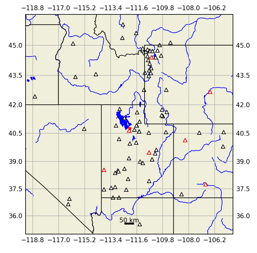
Utah sits in an active seismic zone and the region is well instrumented by seismometers (see the figure below). Fortunately, there are also three infrasound arrays operating in Utah (red triangles in the map, which I’ve actually helped support over the years) that are operated by University of Utah. There are also a smattering of infrasound sensors in Colorado and Wyoming.

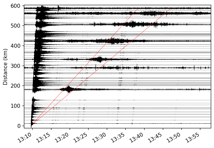
When you know about an event, one of the best ways to look at seismic or infrasound data from a network of stations is to plot a ‘record section’ (see Figure below). A record section shows each recording (seismic and infrasound) arranged by distance from the earthquake epicenter, so you can see the evolution of the waves as they travel out from the source. The record section for the March 18th earthquake, shown below, highlights a few things. First, the seismic waves generated by the M 5.7 earthquake can be seen arriving just before 13:10 at the closest station, and a couple of minutes later at 600 km. These signals extend over a few minutes at the more distant stations. Next, you can see signals from at least four aftershocks – these are the small signals with the same ‘moveout’ (or velocity across the network) as the mainshock. Finally, the infrasound signals are the long-duration arrivals between the red lines. Because mechanical waves travel much slower through air than through the ground, they’re much later than the seismic signals from the mainshock, and overlap with the aftershocks.

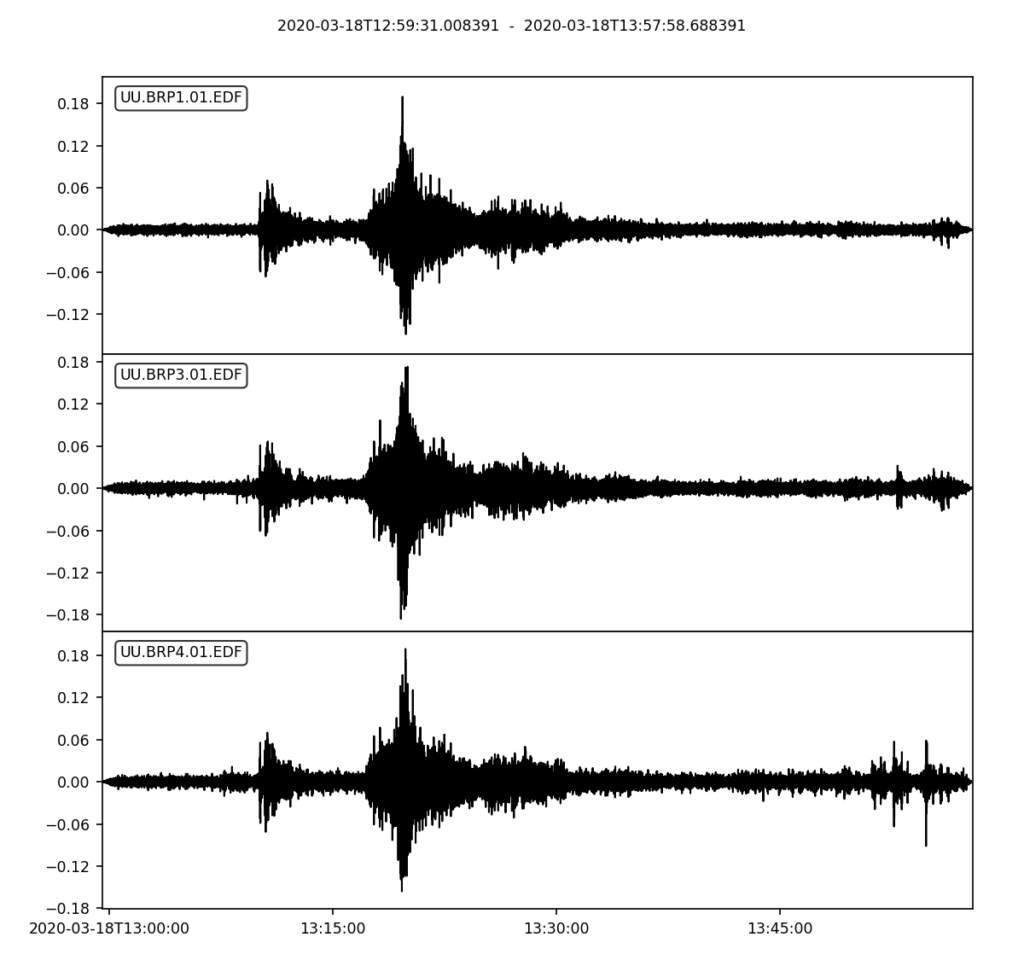
The station at around 200 km is an array of infrasound sensors that is designed to enable us to measure the direction of the signal (or ‘backazimuth’, which is the azimuth the signal comes from). Because they’re infrasound sensors, we can also measure the amplitude (the pressure, in Pascals) of the signals (see the figure below).

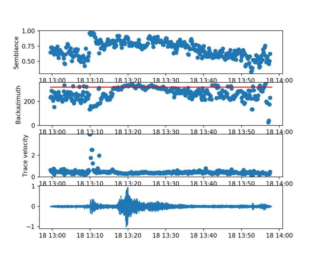
Using techniques developed to process array data, we can calculate the backazimuth (and a few other things) as a function of time (see figure below). Ignoring everything except the second and fourth panels for now, we can see that the backazimuth of the strongest signal is consistent with infrasound from the earthquake.

We’re only recently starting to realize that this isn’t all a scientific curiosity: infrasound tells us about how the ground moves, not just near the earthquake, but over much broader regions. We can use infrasound observations to reconstruct ground motions in areas with no seismometers. Because theres so few infrasound sensors (especially arrays) compared to seismometers, any data we can get to help us understand these processes is critical. Utah has come good again!
Interested in what an earthquake sounds like? We can speed up the recording 100 times to simulate what it would sound like to us: